

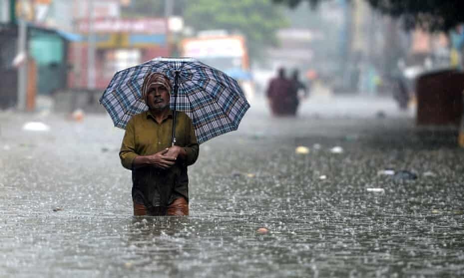
A well-marked low over the Bay of Bengal is forecast to strengthen through the weekend, bringing heavy rain to north Tamil Nadu and Chennai. This is textbook post-monsoon (Northeast monsoon) behaviour for peninsular India—exactly when the Bay is warmest and the steering winds funnel moisture toward the Coromandel coast.
The Indian monsoon system — the big picture
Southwest (Summer) Monsoon — June to September
-
Driver: Differential heating of land and ocean plus cross-equatorial flow; low pressure over northwest India draws moist southwesterlies from the Arabian Sea and southeasterlies from the Bay of Bengal.
-
Onset & spread: Starts over Kerala in early June, advances northwestward; rainfall peaks in July–August.
-
Rainfall core: Western Ghats, central India, northeast India, and the Ganga plains.
-
Withdrawal: Begins from northwest India in late September, retreating southeastward.
Northeast (Retreat/Post-monsoon) Monsoon — October to December
-
Driver: With the SW monsoon withdrawn, the land cools faster than the ocean; continental high pressure forms over North India, pushing northeasterly/easterly trade winds toward the Bay.
-
Why Tamil Nadu gets rain now: The Western Ghats block SW monsoon rains for Tamil Nadu in summer. In Oct–Dec, winds blow from land to sea, pick up moisture over the Bay, and return to dump rain on the Coromandel coast—hence Chennai’s wettest months are typically Nov–Dec.
-
Boosters: Fresh low-pressure areas, depressions, and cyclones over the Bay act like rain engines for coastal Andhra–TN–Puducherry.
Western Disturbances — winter rain makers in the north (Oct–April; peak Dec–Feb)
-
What they are: Extratropical (mid-latitude) low-pressure systems that ride the subtropical westerly jet from the Mediterranean/Caspian region into northwest India and the Himalaya.
-
Weather signature: Rain/snow over J&K–HP–Uttarakhand, cloudy, cooler spells and winter rain over Punjab–Haryana–Delhi–Rajasthan–UP; occasional hail and thunder when they interact with low-level moisture.
-
Why they matter: Crucial for rabi (wheat, mustard) moisture, replenishing glaciers/snowpack; but strong WDs can also trigger avalanches, landslides, and cold waves.
Cyclones in the North Indian Ocean — when and where
-
Basins: Bay of Bengal (BoB) and Arabian Sea (AS). The Bay usually spawns more and stronger systems because of warmer waters, larger fetch, and favourable wind patterns.
-
Two seasonal peaks:
-
Pre-monsoon (late April–June) — classic May peak.
-
Post-monsoon (October–December) — classic November peak (most active for Tamil Nadu–Andhra coasts).
-
-
Intensity ladder (3-min winds):
-
Low Pressure Area (LPA) → Depression (~31–49 km/h) → Deep Depression (~50–61 km/h) → Cyclonic Storm (≥62 km/h, gets a name) → Severe/Very Severe/Extremely Severe Cyclonic Storm → Super Cyclone (≥222 km/h).
-
-
Tracks now: In Oct–Nov, storms forming in the southwest/west-central BoB often track west–northwesttoward the Andhra–TN coasts or north toward Odisha–WB, guided by steering ridges and troughs aloft.
Why Chennai and north coastal Tamil Nadu are on alert now
-
Warm Bay + active NE monsoon: Sea-surface temperatures are high; northeasterlies feed moisture into the system.
-
Favourable shear window: Vertical wind shear can briefly align to let the low consolidate into a depression → deep depression → cyclonic storm, enhancing organized rainbands toward the coast.
-
Orography and coastal geometry: The east-facing Coromandel is directly exposed to onshore flow; any slow-moving or coast-hugging system can train rainbands over Chennai and neighbouring districts, causing very heavy spells.
Time of the year — a quick calendar
-
June–Sept: Southwest monsoon (pan-India summer rains).
-
Oct–Dec: Northeast monsoon (Tamil Nadu’s main rainy season; Bay cyclones common).
-
Oct–Apr (peak winter): Western Disturbances (north and northwest India rains/snow).
-
Cyclone peaks: May and Nov; Bay systems dominate the post-monsoon season.
What to watch with the current Bay system (public-safety lens)
-
Rainfall bands & timing: Heaviest bursts often occur pre-landfall in outer bands and again near the core’s passage; urban flooding risk rises during high-intensity, short-duration spells.
-
Wind & surge near landfall: Even a cyclonic storm can bring gale-force winds, rough to very rough seas, and minor coastal inundation along low-lying stretches.
-
Secondary hazards: Waterlogging, tree fall, power disruption, and traffic bottlenecks; inland areas can see flooding of low-lying roads and underpasses.
-
Preparedness tips: Secure outdoor items, clear terrace drains, avoid driving through waterlogged underpasses, follow official advisories on school/office schedules and fishing bans.
Quick glossary
-
Monsoon: Seasonal reversal of winds due to land–sea thermal contrast and large-scale circulation shifts.
-
Northeast monsoon (NEM): Oct–Dec rains over southeast peninsular India driven by northeasterlies and Bay systems.
-
Western Disturbance (WD): Mid-latitude westerly trough/low bringing winter rain/snow to north India.
-
Depression/Deep Depression/Cyclonic Storm: Successive intensity stages of a tropical system based on sustained wind speed.
-
Storm surge: Abnormal sea-level rise near landfall from wind stress and pressure drop.